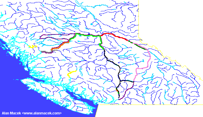
Surveying in 1876
The main tasks completed this season were the completion of the route from Fort George (now Prince George) to Tete Jaune Cache and the Yellowhead Pass. Also a route was located up the Dean River and north to the Nechako River. At the end of the season, three survey crews surveyd the Fraser Canyon between Chapman's Bar and Lytton.
The official report for surveys in 1876 was written by Henry Cambie instead of Marcus Smith (more on Marcus Smith). Unfortunately, Cambie did not write as verbous a report as Smith so there is much less information to work with.

The Survey Crews
X
(Yellow) This group left Victoria under the leadership of C. H.
Gamsby (more on Gamsby) on the steamer "Sir James Douglas" on February 2nd for Gardner's Inlet. Due to ice in the inlet, they didn't get to mouth of the Kitlope River on March 6. They surveyed up the Kitlope and a creek now called the Gamsby River to the summit with the Kimsquit drainage. They returned to the ocean on April 3rd and paddled by canoe to Kemano by April 11th where they rejoined their steamer. They returned to Victoria on April 16th via Bella Bella.
Later in the season, they left Victoria mid May (all the survey groups left between May 11 and May 26th). They arrived in Bute Inlet and completed about 20 miles of location survey in the East Homathco Valley that was not completed in 1875. They also revised some sections to improve the route. They completed their work on October 19 and returned to Victoria by October 22.
N
(Red) Operating under H. P. Bell (more on Bell), they had spent the winter at Fort George (now Prince George) and in the spring worked on a location survey east up the Fraser River towards M. They connected their survey with 'M' on October 5th.
M
(Dark green) Led by Mr. George Keefer (more on George Keefer), they wintered at Tete Jaune Cache. During the winter they explored possible routes down the Fraser River towards Fort George. After the snow left, they continued their location survey from the previous season. On August 1st, V joined up and assisted with the survey. On October 5th they connected their survey with N.
On their way down the Fraser Canyon, they were asked to survey between Lytton and Chapman's Bar along with Y and S. They were done by November 1st and back in Victoria on November 4th.
V
(Pink) Under Mr. John Trutch (more on John Trutch) leadership, this group left Victoria in mid May to assist M with their location survey from Tete Jaune Cache westward. Because of very high water levels on the North Thompson River, this group took two months to travel from Kamloops to Tete Jaune Cache. They also lost some of their equipment. They began their work on August 1st and the survey was completed on October 5th when 'M' and N connected.
R
(Gray) Under Mr. Jennings (more on Jennings), this group located a line for 50 miles up the Dean River. They left Victoria in mid May, completed their work on September 19th and were back in Victoria on October 7th.
Y
(Orange) Led by Mr. Joseph Hunter (more on Joseph Hunter), they left Victoria in early June with Henry Cambie for the Dean River on June 13th. On July 5th, they worked on an exploratory survey via the Iltasyuko River and Sigutlat Lake towards the Nechako River. They connected their survey with S on September 29th.
On their way back to Victoria, they were intercepted by Cambie and asked to survey the Fraser Canyon between Lytton and Chapman's Bar along with M and S. They were done and back in Victoria on November 15.
S
(Green) This was under Mr. McMillan (more on McMillan). They travelled up to the mouth of the Chilako River near Prince George. They then ran an exploratory survey up the Nechako River. On September 29th, they completed their survey when they connected with Y.
On their way back to Victoria, they were intercepted by Henry Cambie and asked to survey the Fraser Canyon between Lytton and Chapman's Bar along with M and Y. They were done on November 1 and back in Victoria on November 4.
The People
Henry Cambie
(Purple) Cambie was put in charge of surveys in British Columbia for this season because Marcus Smith (more on Marcus Smith) was acting Engineer-in-Chief while Sandford Fleming (more on Sandford Fleming) was in England.
Cambie travelled up the coast with Mr. Hunter and Y to the mouth of the Dean River on June 13th. They met their mule train which arrived on July 5th from Quesnelle. Somehow Cambie made his to Fort Fraser (near Fraser Lake). He left Fort Fraser on August 26th and was at the west end of Lake Francois on August 30th. Further westward, he was overlooking Lake Tahtsa on September 6th. He travelled east via Lake Ootskabunkut Lake (now Ootska Lake - the reservoir for the Kemano generator plant) to the Nechako River.
In early October, Cambie was in Kamloops ensuring the survey groups got back from the field. He then travelled via the Nicola and Coquihalla valleys to Fort Hope. He then met Mr. Keefer (M), Mr. Hunter (Y) and Mr. McMillan (S) and sent them to locate a line in the Fraser Canyon between Chapman's Bar and Lytton. The section between Yale and Chapman's Bar was completed in 1874.
References
- Fleming (1877) - Report, especially,
- Appendix J - Winter on Inlets by C. H. Gamsby
- Appendix K - Memorandum Regarding the Surveys in British Columbia, Giving an Outline of Operations Carried out During the Year 1876 by H. J. Cambie
- Appendix ZA - Progress Report on Surveys Carried on During the Year 1876 by Marcus Smith