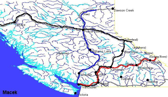
Map of Southern British Columbia
From AlanMacek.com Canyon
Showing some cities, roads, railways and passes of the region.

Legend
- Black dots - random cities, not necesarily the largest or most significant
- (pass) - some of the mountain passes surveyed for the CPR, approximate location
- grey line - highways. The highways shown are:
- 1 - Vancouver, Hope, Lytton, Kamloops, Revelstoke, Golden, Calgary
- 3 - Vancouver, Hope, Osoyoos, Castlegar, Cranbrook, Lethbridge
- 16 - Prince Rupert, Terrace, Prince George, Jasper, Edmonton
- 97 - Kamloops, Cache Creek, Williams Lake, Prince George, Chetwynd, Dawson Creek
- 99 - Vancouver, Squamish, Whistler, Lillooet, Cache Creek
- black line - Canadian National. Vancouver, Hope, Kamloops, Blue River, Yellowhead Pass
- red line - Canadian Pacific Railway. Vancouver, Hope, Kamloops, Revelstoke, Golden, Kicking Horse Pass
- blue line - British Columbia Railway (now part of CN). Vancouver, Squamish, Williams Lake, Prince George, Dawson Creek
Note: Only the mainline for each of the railways is shown.
Each of the railway companies has maps of their railway networks.
- Canadian Pacific Railway - www.cpr.ca -> Network Map
- Canadian National Railway - www.cn.ca -> click on map