Fraser River: Difference between revisions
No edit summary |
No edit summary |
||
| Line 1: | Line 1: | ||
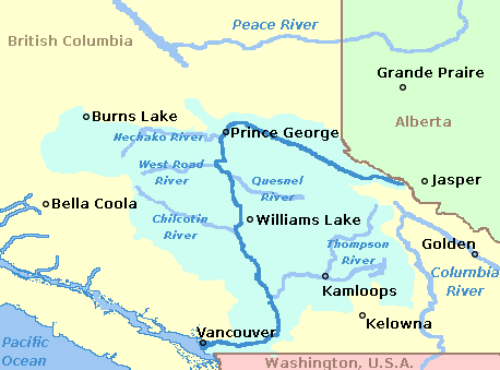
[[Image:FraserRiverBritishColumbia_Location.png|frame|Map showing Fraser River and its major tributaries]]The [[Fraser River]] is one of the major rivers in British Columbia. It starts near the [[Yellowhead Pass]] in the Rocky Mountains. It then flows north before curving south through [[Prince George]] and then south through the interior plateau and the Coast Mountains. It ends in Georgia Strait at [[Vancouver]]. | [[Image:FraserRiverBritishColumbia_Location.png|frame|Map showing Fraser River and its major tributaries]]The [[Fraser River]] is one of the major rivers in British Columbia. It starts near the [[Yellowhead Pass]] in the Rocky Mountains. It then flows north before curving south through [[Prince George]] and then south through the interior plateau and the Coast Mountains. It ends in Georgia Strait at [[Vancouver]]. | ||
__NOTOC__ | |||
==Major Features== | |||
===[[Fraser Valley]]=== | |||
Between [[Hope]] to its mouth near Vancouver, the river flows though a wide valley with many side channels. The land is generally rich and suitable for farming. Paddlewheelers served the communities along this stretch of the river as far as [[Yale]] (about 10km upstream from [[Hope]]). | |||
Today, the Fraser Valley contains many of the suburbs of Vancouver as well as farming. | |||
{{Wikipedia|Fraser River}} | ===[[Fraser Canyon]]=== | ||
Between [[Hope]] and [[Lytton]] the river flows south through a gorge. This canyon is a significant barrier to all forms of transportation including Indians, gold seekers, boats, railways and highways. At the start of the canyon, the Fraser River is joined by its most significant tributary, the [[Thompson River]]. | |||
The [[Cariboo Road]] was built in the 1860s to connect [[Yale]], the head of navigation, to the gold fields in the Cariboo region near Barkerville. This road was a major feat of engineering for a small colony. | |||
In the 1880s, [[Andrew Onderdonk]] built what became the Canadian Pacific Railway through the canyon by blasting almost continuous tunnels and bridges. In the 1910s, a second railway was built through the canyon became is now the Canadian National Railway. | |||
The transcanada highway was also built through the canyon. | |||
===[[Upper Fraser River]]=== | |||
This usually refers to the section of the river upstream from [[Prince George]]. This section is generally navigable but does have some significant rapids. A highway and the Canadian National Railway parallel this section of the river. | |||
==See Also== | |||
*{{Wikipedia|Fraser River}} | |||
*{{Wikipedia|Cariboo Road}} | |||
[[Category:Geographic Features]] | [[Category:Geographic Features]] | ||
Latest revision as of 20:23, 4 December 2005

The Fraser River is one of the major rivers in British Columbia. It starts near the Yellowhead Pass in the Rocky Mountains. It then flows north before curving south through Prince George and then south through the interior plateau and the Coast Mountains. It ends in Georgia Strait at Vancouver.
Major Features
Fraser Valley
Between Hope to its mouth near Vancouver, the river flows though a wide valley with many side channels. The land is generally rich and suitable for farming. Paddlewheelers served the communities along this stretch of the river as far as Yale (about 10km upstream from Hope).
Today, the Fraser Valley contains many of the suburbs of Vancouver as well as farming.
Fraser Canyon
Between Hope and Lytton the river flows south through a gorge. This canyon is a significant barrier to all forms of transportation including Indians, gold seekers, boats, railways and highways. At the start of the canyon, the Fraser River is joined by its most significant tributary, the Thompson River.
The Cariboo Road was built in the 1860s to connect Yale, the head of navigation, to the gold fields in the Cariboo region near Barkerville. This road was a major feat of engineering for a small colony.
In the 1880s, Andrew Onderdonk built what became the Canadian Pacific Railway through the canyon by blasting almost continuous tunnels and bridges. In the 1910s, a second railway was built through the canyon became is now the Canadian National Railway.
The transcanada highway was also built through the canyon.
Upper Fraser River
This usually refers to the section of the river upstream from Prince George. This section is generally navigable but does have some significant rapids. A highway and the Canadian National Railway parallel this section of the river.
See Also
- See the Wikipedia article on.
- See the Wikipedia article on.