File:CanadianPacificRailwayNetworkMap.png: Difference between revisions
From AlanMacek.com Canyon
No edit summary |
m (+map) |
||
| Line 2: | Line 2: | ||
Created by [[User:Al guy]] on December 9, 2004. Map drawn in [[GIMP]]. Underlying data is public domain courtesy of United States Bureau of Transportation Statistics [http://www.bts.gov/publications/north_american_transportation_atlas_data/]. Mainline railway location based primarily from ''Canadian Pacific Railway 2004 Corporate Profile and Fact Book'' at page 11 (Assets). [http://www8.cpr.ca/cms/English/Investors/Fact+Book/default.htm] | Created by [[User:Al guy]] on December 9, 2004. Map drawn in [[GIMP]]. Underlying data is public domain courtesy of United States Bureau of Transportation Statistics [http://www.bts.gov/publications/north_american_transportation_atlas_data/]. Mainline railway location based primarily from ''Canadian Pacific Railway 2004 Corporate Profile and Fact Book'' at page 11 (Assets). [http://www8.cpr.ca/cms/English/Investors/Fact+Book/default.htm] | ||
{{Map}} | |||
Latest revision as of 15:35, 22 February 2005
Network map of the Canadian Pacific Railway
Created by User:Al guy on December 9, 2004. Map drawn in GIMP. Underlying data is public domain courtesy of United States Bureau of Transportation Statistics [1]. Mainline railway location based primarily from Canadian Pacific Railway 2004 Corporate Profile and Fact Book at page 11 (Assets). [2]
File history
Click on a date/time to view the file as it appeared at that time.
| Date/Time | Thumbnail | Dimensions | User | Comment | |
|---|---|---|---|---|---|
| current | 15:16, 22 February 2005 | 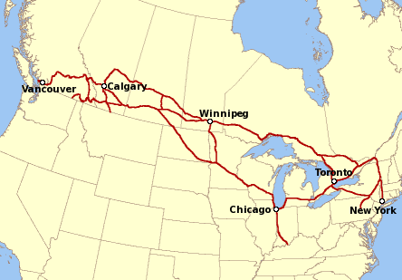 | 444 × 309 (56 KB) | Alan (talk | contribs) | CPR Map |
Links
There are no pages that link to this file.