File:ThompsonRiverBritishColumbia Location.png: Difference between revisions
From AlanMacek.com Canyon
No edit summary |
No edit summary |
||
| (One intermediate revision by the same user not shown) | |||
| Line 5: | Line 5: | ||
Created by [[User:al guy]] on August 13, 2004 | Created by [[User:al guy]] on August 13, 2004 | ||
Colours are based on the discussions at [[Wikipedia talk:WikiProject Maps]]. Map drawn in GIMP. | Colours are based on the discussions at [[Wikipedia talk:WikiProject Maps]]. Map drawn in GIMP. | ||
{{NaturalResourceCredit}} | |||
{{Map}} | |||
Latest revision as of 22:04, 5 July 2005
Thompson River, British Columbia - Map
This map shows the location of the Thompson River, including drainage and major lakes.
Created by User:al guy on August 13, 2004 Colours are based on the discussions at Wikipedia talk:WikiProject Maps. Map drawn in GIMP.
Underlying data © 2003. Government of Canada with permission from Natural Resources Canada and used under license. Copyright in the map itself is owned by Alan Macek.
File history
Click on a date/time to view the file as it appeared at that time.
| Date/Time | Thumbnail | Dimensions | User | Comment | |
|---|---|---|---|---|---|
| current | 15:12, 22 February 2005 | 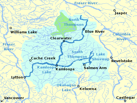 | 453 × 340 (29 KB) | Alan (talk | contribs) | Thompson River locator map |
Links
The following pages link to this file: